■Round-trip mileage: 4.1 miles
■Difficulty: Moderate+
■Elevation: Start 846 feet, Summit: 1582 feet, Total Ascent 1038 feet.
■Warning: Rattlesnakes have been spotted on this trail during warm, summer months.
View Dallas Road Skyline Trailhead in a larger map
Icy Dallas/Badger/Skyline Hike blog posting
To get to the Badger Mountain Skyline Trail, also known as the Dallas Road Badger Mountain Trail, you can approach from two directions. From Interstate 82, take the Dallas Road Exit #104 and head north for 1.8 miles. On the right side, you’ll see a warehouse. Turn right and go up the gravel road about 100 yards to the trailhead parking area. The other approach is from I-182. Take the Queensgate Exit (#3 if you’re coming from the south, #3a if coming from the north). Follow Queensgate south to the signal light at Keene Road. Turn right on Keene and go 2.1 miles to the roundabout at Bombing Range Road. Turn left and you’ll be on Dallas Road. Go 1.4 miles to the warehouse on left. Turn left up gravel road to trailhead parking area.
The Hike
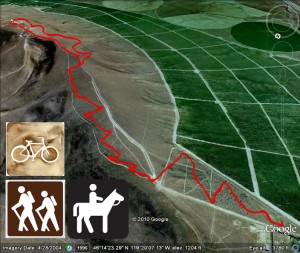
This hike begins from a large parking lot, complete with outhouse and kiosk with maps and events and information. The first part winds and climbs gradually through virgin sagebrush. As you reach the top of the sagebrush field, you’ll cross over the roadway with allows vehicle access to the communication towers on top of Badger Mountain. You can follow this road but I think its more scenic and enjoyable to stick to the trail. Across the road, you can get back on the trail and you’ll get your first great view of Richland, West Richland and the Hanford Nuclear Reservation. Following a few switchbacks, you’ll continue climbing up the ridge. You’ll pass a granite marker where geologists believe the old Lake Lewis crested after the break of the dam released Lake Missoula to flood our area, creating the Channeled Scablands, part of the beauty of Eastern Washington. At this marker you have a great view west to Rattlesnake Mountain, you can pick out the plume of the Columbia Generating Station nuclear plant, you can also pick out other Hanford site landmarks like the Fast Flux Test Facility. Continuing up the mountain, you’ll hike through desert grasses. There are plenty of flowers in the spring. As you reach the spine of this ridge, you’ll again cross the access road. The trail continues on the other side of the road. At this point you have a view of the Horse Heaven Hills, Badger Canyon and west into the lower Yakima Valley. The trail winds around the south or “back” side of Badger Mountain, wandering in and out of the various draws. You’ll pass a couple communication towers then come to a fork in the trail. Follow the left fork. The right fork will take you back down to Trailhead Park via the Sagebrush Trail. Follow the trail up to the tower and enjoy the view! On a clear day, you can see the Blue Mountains to the east along with the Tri-Cities, Columbia and Yakima Rivers, Hanford and Badger Canyon. On a pristine day, you may get a glimpse of Mt. Adams.
You can either retrace your steps to go back down but I like to follow the road back to where the upper trail crosses and then take the trail back down (as shown in the above image). This is an enjoyable hike but it is longer than the Family Trail or Sagebrush Trail so plan accordingly. If you are a vigorous hiker, you can reach the top in about 30-35 minutes. It is 2.1 miles from the trailhead to the top of the mountain.
Click the video below to view a panorama from the top of Badger Mountain.


