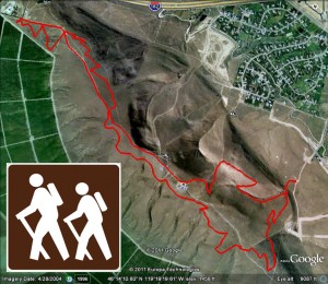
■Round Trip Mileage: 6.3 miles
■Difficulty: Difficult
■Elevation: Start 715 feet, Summit: 1579 feet Total Ascent: 2189 feet
■Warning: Rattlesnakes have been spotted on this trail during warm, summer months.
View Trailhead Park Map Use in a larger map
The Badger Mountain Canyon (I like to call it the Family Trail), Sagebrush, and this Long Loop trail all start at Trailhead Park. Trailhead Park is at 525 Queensgate Drive in Richland. From I-182, take the Queensgate exit heading south to the light at Keene Road. Turn west on Keene Road to the signal light at Shockley Road near the Bethel Church. Turn south and follow the road up the hill. It will veer left and turn into Queensgate, follow the road up the hill past the Westcliffe pillars to the park at the top of the road. There is a parking area at the corner of Queensgate and White Bluffs or you can park along the curb near the restrooms at the park. This can get a little congested in the summer when trail use is heavy.
If you’d like a longer hike on Badger Mountain, this is the ticket. You actually end up climbing the mountain twice but, with this route, you never retrace your steps except at the beginning where you climb the steep stairs just south of Trailhead Park.From Trailhead Park, climb the stairs to the fork in the trail. Turn left to the Sagebrush Trail, follow it up and stay to the right at the next fork. Follow this trail across the old-growth sagebrush part of Badger Mountain, continue on as it crosses the road and winds around the south side of the mountain. As you near the communications towers on the top, stay on the trail to the left. Follow the trail across several draws on the south side of the mountain. As the trail hits the road again, turn left and take the road down the west end of the mountain. You’ll arrive at the Skyline or Dallas Road Trailhead where you can take a break with an outhouse available in the parking area. Go to the kiosk and head back up the mountain on the switchback trail through more sagebrush. You’ll cross the road again, keep going on the trail. Work your way up to a nice vantage point view of Benton city and the Lower Yakima Valley to the west. You’ll also pass a Lake Lewis marker showing the water level during the floods that created our beautiful Channeled Scabland area. When you get to the road again, turn left and follow the road to the top. Pass the first two communications towers and head down the trail to the left at the second set of towers. You’ll see the yellow “hikers only” sign along the trail. This is the Canyon or Family Trail is I like to call it. It winds back down to Trailhead Park and you’ve completed a 6.3 mile loop without any retraced steps! Total hike time for me was a little under 2 hours.


